NOTE: Rocky Mountain Complex Incident Management Team (CIMT) 1 is managing the Cottonwood and Morrill Fires under the direction of the State of Nebraska.
Special Note: The Morrill Fire’s 71,277-acre increase is not due to fire growth that occurred on Tuesday. Rather, a mapping flight—the first since Sunday evening—provided more accurate data on the current fire perimeter. Due to a lag between map production and crews reporting their progress at end of shift, containment is actually more than what is depicted on today’s maps and will be reflected in this evening’s reported statistics and tomorrow’s maps.
Current Situation: Despite strong winds developing as expected Tuesday, neither the Cottonwood nor Morrill Fires grew notably beyond their current perimeters. Active fire behavior occurred within the existing fire perimeters. All resources continue to work cooperatively on the fire-suppression effort, constructing firelines directly at the fire’s edge and extinguishing areas of heat as they work their way around each fire’s perimeter. Structure-protection crews also remain in place on both fires. And should a new fire start in the area, firefighters assigned to both Cottonwood and Morrill Fires are available and ready to respond quickly. Both fires are also being staffed overnight.
Cottonwood Fire: Tuesday afternoon, the Cottonwood Fire experienced strong winds for about two hours. Fire activity was greatest in Division G, the fire’s southeastern half. However, crews reported that the burning vegetation was within the fire perimeter. Existing containment lines were not threatened and successfully held the fire in place. In the northwestern Divisions A and D, rugged areas with more woody vegetation are retaining the most heat. Where engines cannot access the fire’s edge, four hand crews are accessing the fire’s edge on foot, constructing fireline and extinguishing hotspots.
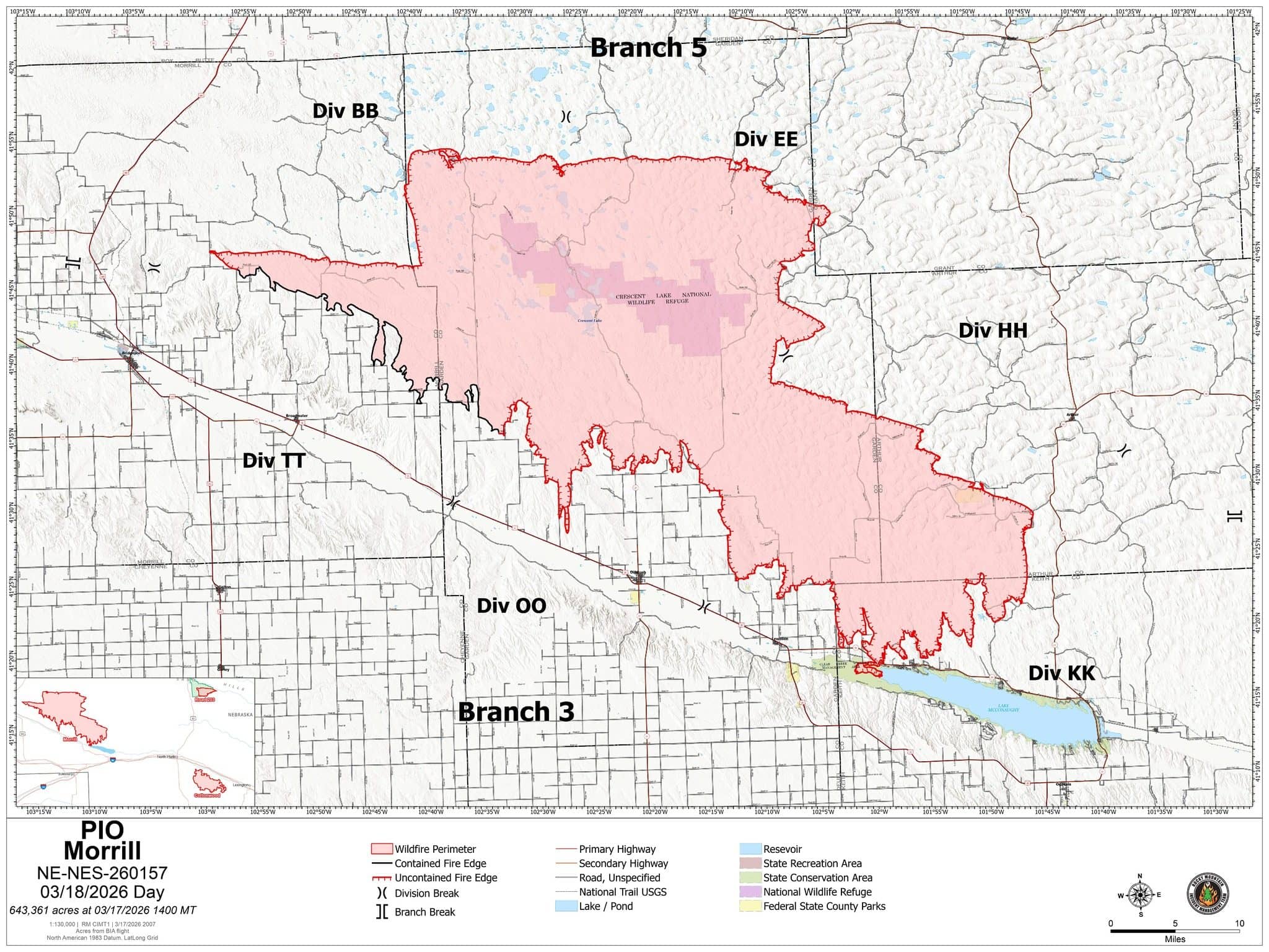
Morrill Fire Map
Morrill Fire: Gusty winds Tuesday caused unburned vegetation within the fire perimeter to ignite and burn actively, particularly on the fire’s eastern and southeastern sides in Divisions HH and KK. Several local volunteer fire departments responded, coordinating with the firefighting resources managed by Rocky Mountain CIMT 1. Blowing dust, smoke, and ash severely restricted visibility, but crews extinguished all of the flareups and successfully kept the fire from escaping its current perimeter.
Weather and Fire Behavior: Because hot, dry, windy conditions persist, a red flag warning is in effect Wednesday from 11 a.m. MDT to 7 p.m. MDT. Unburned vegetation within the fire perimeters could continue to ignite and readily burn. Should any new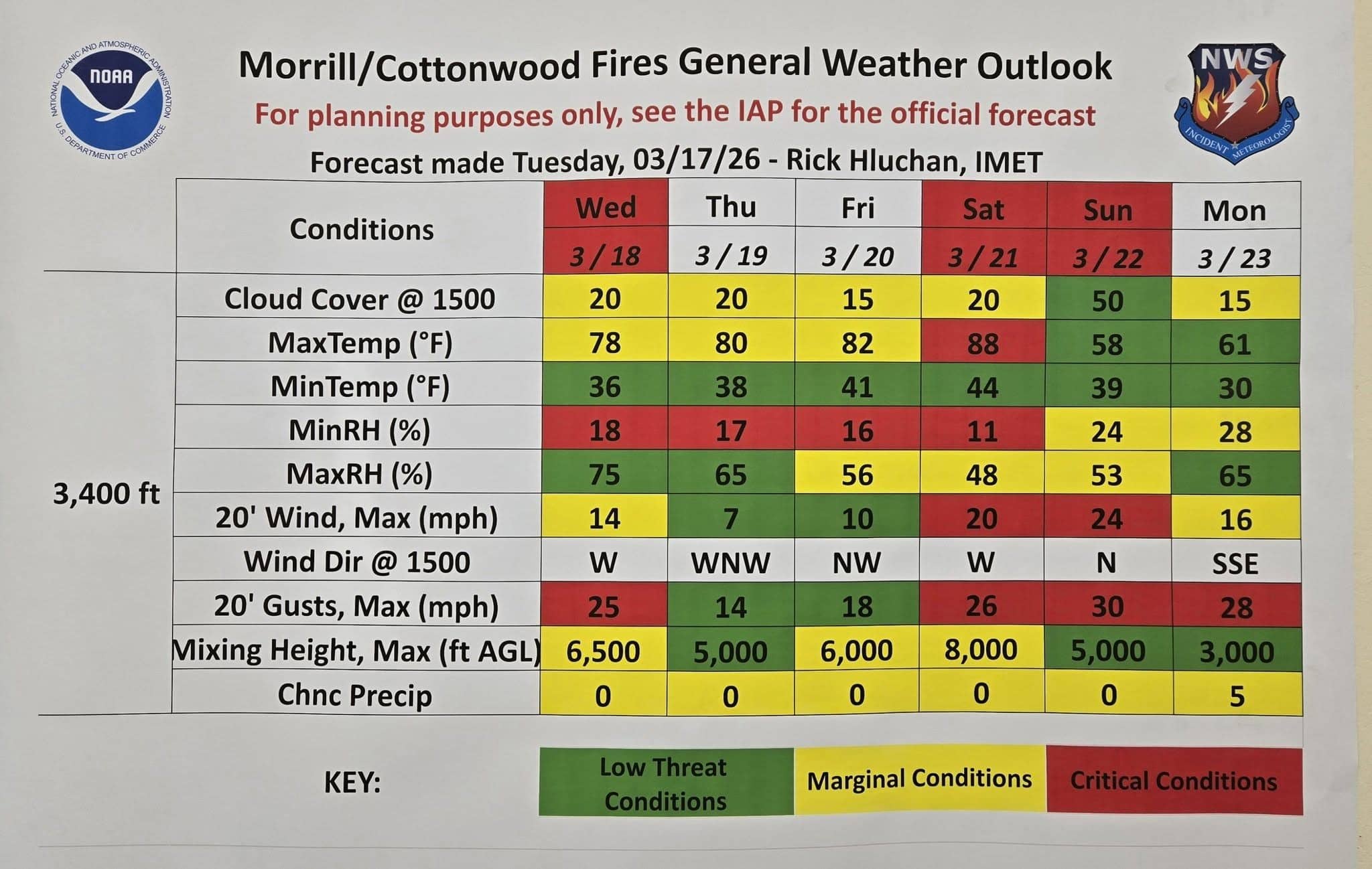 fires start in the area, they will likely spread rapidly. If wildfire smoke is affecting your area, refer to the Air Now website, specifically the Fire and Smoke Map (Fire.AirNow.gov) to monitor air quality and get information on reducing your smoke exposure.
Temporary Flight Restrictions (TFR): TFRs (tfr.faa.gov) are in place over both fires. Wildfires are no-fly zones for unauthorized aircraft, including drones. If you fly, we can’t. For more information, visit knowbeforeyoufly.org.